Where Is the Pangolin?
You think Google or Microsoft should have built this. They didn't. A small South African startup did.
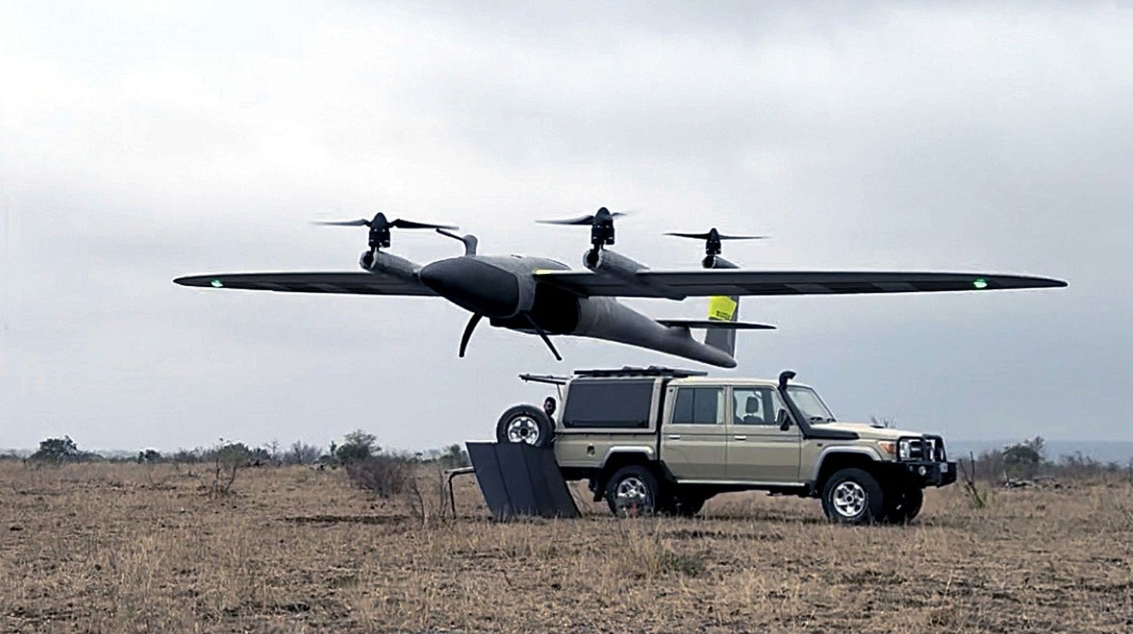
A couple of weeks ago, something incredible happened. A small team of technologists conducted what I believe is the most sophisticated and accurate wildlife census ever done in Africa.
No fanfare. No press tour. Across an area roughly the size of Berlin, more than 100,000 hectares of some of the world's most iconic wildlife game reserves. Self-funded. And the results have been startling.
So who are these people? And why did they do it?
| What | Project GAIA: the most sophisticated drone-based wildlife census ever conducted in Africa |
| Who | Willem Kellerman, Dirk Strauss, and Johan Dannhauser (Chisl / Veriphy Tech) |
| Where | Sabi Sands, Timbavati, Kwandwe, and Karongwe game reserves (140,000+ hectares) |
| Key finding | A straight-down satellite view misses more than 4 out of 5 animals. Multi-angle drone imagery found 30-40% more animals than traditional methods. |
| Reading time | 8 minutes |
It Started With a Drone and a Deck in the Bush
The vision started with Willem Kellerman, co-founder of Chisl and Veriphy Tech, alongside his co-founders Dirk Strauss and Johan Dannhauser.
It began when Willem's passion for wildlife and technology collided into a single question: could you use drones to capture images of wildlife across large African wilderness, then use machine learning to train and identify everything, and deliver insights never done before at this scale using a commercial platform?
From trees to impala to leopard to pangolin. We'll get to the pangolin, bear with me.
So Willem did what any reasonable person would do when they decide to revolutionise wildlife conservation. He went out into the South African bush, slept on his family's deck and started taking images of African wildlife.
That was the beginning.
For decades, wildlife censuses had been done the same way. Helicopters. Planes. Pilots and spotters peering out of windows at speed, trying to estimate what they could see below. The industry openly acknowledges a margin of error of 20 to 30 percent depending on the species. For some species, possibly more. And the process is invasive: there are examples of elephant herds breaking through fences and remaining unsettled days after a census flight, long after the aircraft have gone.
Willem believed technology had finally caught up with the problem.
Sabi Sands Said Yes
With all the confidence that passion and naivety bring, Willem picked up the phone and called Sabi Sands.
Five days later he drove down to the lowveld and pitched an idea proven at small scale, built on a few back-of-the-envelope calculations for a project this size. He believed, based on initial results, that they could orchestrate a successful drone census across 45,000 hectares in less than five days.
One experiment. One phone call. That's all it took. That, and three special experts in conservation.
Sabi Sands, one of the most progressive game reserves in the world when it comes to conservation technology, said yes. As the conversations grew, their neighbours at Timbavati came on board too, and importantly so did both boards of directors.
Without like-minded individuals like Riaan, William and Almero from Sabi Sands and Timbavati, willing to take a chance and embrace technology, investing their own personal time and expertise, this would not have happened. At that moment, with two of the most iconic and prestigious game reserves on board, the project became serious and got a name: GAIA.
At the same time two other reserves put up their hands. Craig from Kwandwe and Edwin from Karongwe, both pushing the envelope of what the platform could and should do.
Suddenly, the project had grown from a solo experiment in the lowveld to a 140,000+ hectare census across some of the most iconic game reserves in Africa.
Personal Skin in the Game
This is where significant credit belongs to Dirk Strauss and Johan Dannhauser, Willem's co-founders and business partners. With full knowledge that the chances of success were uncertain, Dirk matched every rand Willem put in with one of his own, along with his personal time. Johan started focussing on the operational side of the undertaking. No business plan. No guaranteed return. Just a shared belief that this could work.
With personal funds committed and a convincing case made to the engineers at their sister company, the Chisl Group, Willem and Dirk knew they had their team. And they got to work.
If anyone thinks that's easy, think again.
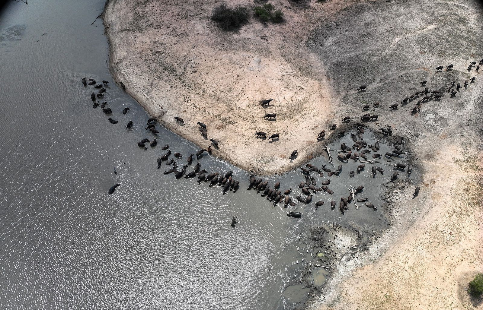
Temperatures exceeding 40 degrees for large parts of the day. Wind gusts of up to 50 kilometres per hour. More than 30 TB of data generated at a rate of over 100MB per second. Three million images. More than 20,000km covered in a straight line. All in some of the wildest wilderness on earth.
In the backend, the challenge was just as big. They had to purpose-build a platform incorporating solutions to bring together the GPS locations of millions of images, developing custom algorithms to accurately identify more than 50 individual species from multiple angles, prevent double counting, create the world's largest drone-captured wildlife dataset, label it, train it, and analyse more than 80 trillion pixels.
They needed computing power. Lots of it.
Another phone call. In stepped Henri and his team at AWS, offering eight of their latest H200 GPUs, providing more processing power than most large corporates have.
With the engineers working across various computer vision detection models, Willem, Dirk and Johan had many sleepless nights, months of labelling, analysing, retraining, analysing and retraining again. Slowly, they were able to show that what they'd built was becoming not just accurate. Incredibly accurate.
The Results
Both Sabi Sands and Timbavati have concurred. The numbers are directionally aligned with traditional methods, but for some species, this census found 30 to 40 percent more animals. Kwandwe and Karongwe found the same.
Numbers that aligned with gut feelings rangers had held for years but could never prove were now shown in plain sight with evidence-based, future-proof science. For every animal, tree, road and water body there was an image, easily accessible, ready to be analysed and ready to contribute to science for years to come.
But it didn't stop at counting animals.
This is rapidly becoming a full ecological census. It mapped water bodies, roads and erosion. The platform is built allowing conservationists to label and train their own data and models, save thousands of points of interest to be analysed next year for changes caused by acts of God, man and flora. Not estimated. Not tracked in isolation. Done with evidence-based analysis at a scale never imagined before.

And during the census, there was a moment that said everything.
A sighting came in. Three lions on a rock. Three game viewers watching. Clients with cameras raised.
Nobody looked up.
Not the lions. Not the guests. The survey was happening overhead and no one, human or animal, knew.
Why Not Just Use Satellites?
If you're wondering why they didn't just use satellites, the answer became clear within the first few days of the census.
Satellite imagery is rarely detailed enough to identify animals on the ground. But more fundamentally, satellites are 90-degree-down view only. Straight down. Anything hiding under canopy, in shade, at an angle, behind a branch, is invisible.
Here's the number that stopped me.
Only 20% of all animals spotted came from a single camera angle.
Think about that. A straight-down view misses more than four out of every five animals.
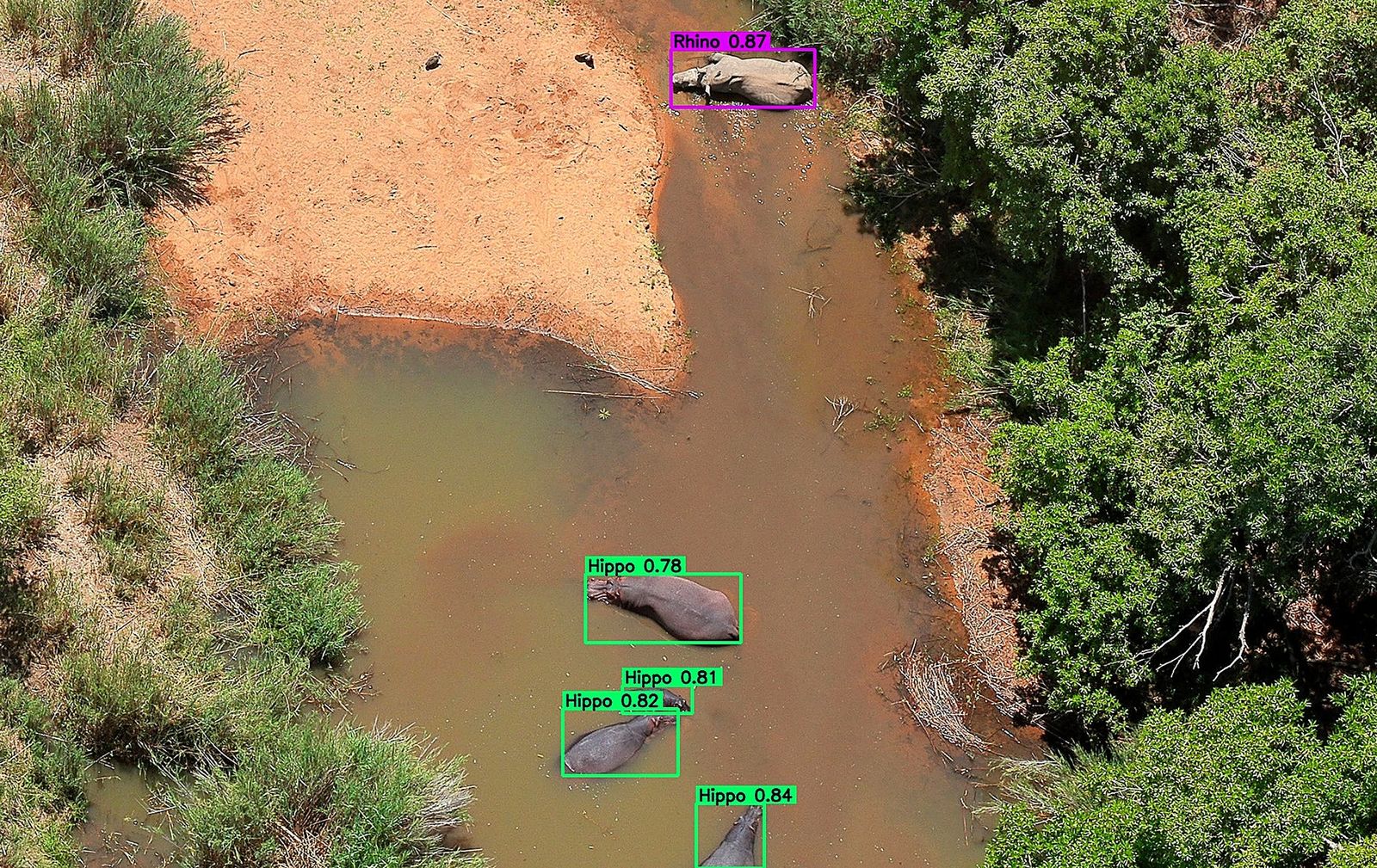
Multiple cameras. Multiple angles. Multiple bespoke, cutting-edge computer vision models trained over hundreds of thousands of images, backed by some of the most powerful computing power available. That's what changed everything.
But What About the Pangolin?
As the results came in and it became clear this was something truly special, identifying most of the typical species of interest from rhino to elephant, but also producing gems like identifying 80% of the lions in one of the enclosed reserves after rerunning and more training, Willem and his co-founders started to wonder whether another crazy idea could also come to life.
Could the platform find a pangolin? Arguably the most elusive living thing in Africa.
If you don't know what a pangolin is, let me explain. It's one of the most trafficked animals on Earth. A small, nocturnal, scale-covered mammal, the only mammal in the world fully covered in keratin scales, the same material as your fingernails. When threatened, it curls into a ball. A defence mechanism that works perfectly against predators and makes it completely defenceless against humans.
Tens of thousands are poached every year for their scales and meat. Elusive. Rarely photographed. Deeply shy. Critically endangered. There are rangers who spend 20 years guiding in the African bush and have never seen one.
Another call, this time to Guts, Toby, Marshall and Donald: some of the most knowledgeable leaders in pangolin conservation. Willem asked: are you interested in helping us build the world's first Pangolin AI model?
"100% we're in," came the answer.
At the time of writing, Donald has taken and labelled more than 2,000 images and is generating more. Many more. Soon this dataset will be added to the model and, with permission, re-run across 140,000 hectares.
Upcoming Virtual Event
Financing Africa's $45bn Used-Car Market
Thursday, 6 August 2026
With Etop Ikpe, Autochek
RegisterColin Iles Media
Put your brand where senior leaders are paying attention.
Sponsor an invitation-only roundtable or fireside interview. We handle the audience, the production, and the content.
Book a strategy call100+ registrations per event · 50%+ email open rates
David, Goliath, and the Point I Keep Coming Back To
Surely this is something Google or Microsoft should have built? With their legions of compute and armies of engineers?
And this is the point I keep coming back to.
Because it proves, again, that in today's world, David is in the ideal position to beat Goliath.
What for Willem, Dirk, Johan and their team was an ambitious but focused project costing a few million rand, would in a large corporate be a project that either hadn't been started, or had already consumed many multiples of that without shipping anything.
Startups have never been more empowered. The access to world-class compute, open-source models, and cloud infrastructure means that small, determined startups can build things that slow-moving corporates have no chance of replicating at the same quality, at the same pace, with the same care.
The technology that Veriphy built is genuinely cutting-edge. Anyone working in computer vision and machine learning will appreciate the complexity of what's been achieved here. And most will be surprised it was done by such a small team.
But the deeper lesson isn't really about the technology.
It's about attitude.
Willpower. Passion. And a refusal to stop.
"It's more a question of the fact that we didn't give up," Willem told me, "than it is of technology breakthroughs or individual brilliance."
Money is available. Technology is accessible. Algorithms can be learned.
Attitude is the thing in short supply.
What's Next
The next goal: one million hectares. A major national park. Surveying 30,000 to 100,000 hectares per day.
This is likely just the first step of something transformational in how we use visual computing to better understand, manage and protect our ecosystems. Not just across Africa. Globally.
No platform will ever identify everything. And neither will this one. God made sure of that. And they still haven't found that pangolin. It probably has a one-in-a-million chance of success, so why even bother considering the importance of the rest?
I don't know. But looking at what this group of passionate conservationists and a small technical startup achieved, would you bet against them?
If you're working in conservation, wildlife management, or ecological research and want to learn more about what the GAIA platform can do, reach out to me directly.
Further reading: Daily Maverick recently published a comprehensive piece on how South Africans are using drones and AI to rewrite the rules of wildlife conservation, featuring Project Gaia: Read the article
The Backroom
Get conversations with senior leaders delivered to your inbox.